Frequently Asked Questions
Expand categories to view frequently asked questions and responses.
Most-Asked Questions
1. What will the project area be like at low tide? Will it smell?
The restored estuary will include tidal flats across the 2-mile project area. The tidal flats will be bordered by other varied habitat types including tidal low marsh, tidal high marsh, tidal forested wetland, and riparian habitats. Visual simulations of the project area based on 15% design at low tide can be viewed on the project page. Most of the time, there will be standing water across the Deschutes Estuary but at low tide, only the main river channel will be filled. The natural ebb and flow of water will change the aesthetics throughout the day.
As part of the design process, DES temporarily lowered water levels in the lake to study underwater features, including the 5th Avenue Dam structure and fish gate, composition of current sediment deposits, and outfall locations. During this summer event, there was no noticeable smell. The presence of a vibrant waterfront along downtown, in an area of tidal influence, also suggests that the naturally occurring odors associated with tidal environments are tolerated by the community. It is also important to note that past discussions around the smell of the waterbody are attributed to wastewater and brewery treatment water; the brewery no longer operates, and wastewater is now sent to the LOTT Central Treatment Plant.
2. What is the sediment quality within the current Capitol Lake?
The Deschutes River and Percival Creek carry the majority of sediment that reaches Capitol Lake. Approximately 32,500 cubic yards of sediment are deposited in the lake annually on average. Percival Creek delivers approximately 1,400 cubic yards of sediment each year. The annual sediment load from these waterbodies varies significantly from year to year. The rate of sediment input is directly related to stream flows, where greater flow rates contribute greater amounts of sediment.
Sediment sampling performed in 2020 to support the Environmental Impact Statement (EIS) showed that, overall, Capitol Lake has sediment quality that meets nearly all applicable sediment criteria. None of the observed metals or organic chemicals concentrations in this sampling event would trigger sediment cleanup, because the detected concentrations were less than the cleanup screening levels and are common in urban areas. Sediment dredged to re-create the historic channels meets beneficial reuse standards in Washington and will be used to create habitat areas throughout the North and Middle Basins.
The sediments in West Bay are impacted by carcinogenic polycyclic aromatic hydrocarbons (cPAHs) and dioxins/furans, and future cleanups are planned by the Port of Olympia to address the contamination. To best support full restoration in the southern terminus of Puget Sound, the Port remediation must occur before the dam can be removed.
3. How does this project improve conditions for salmon?
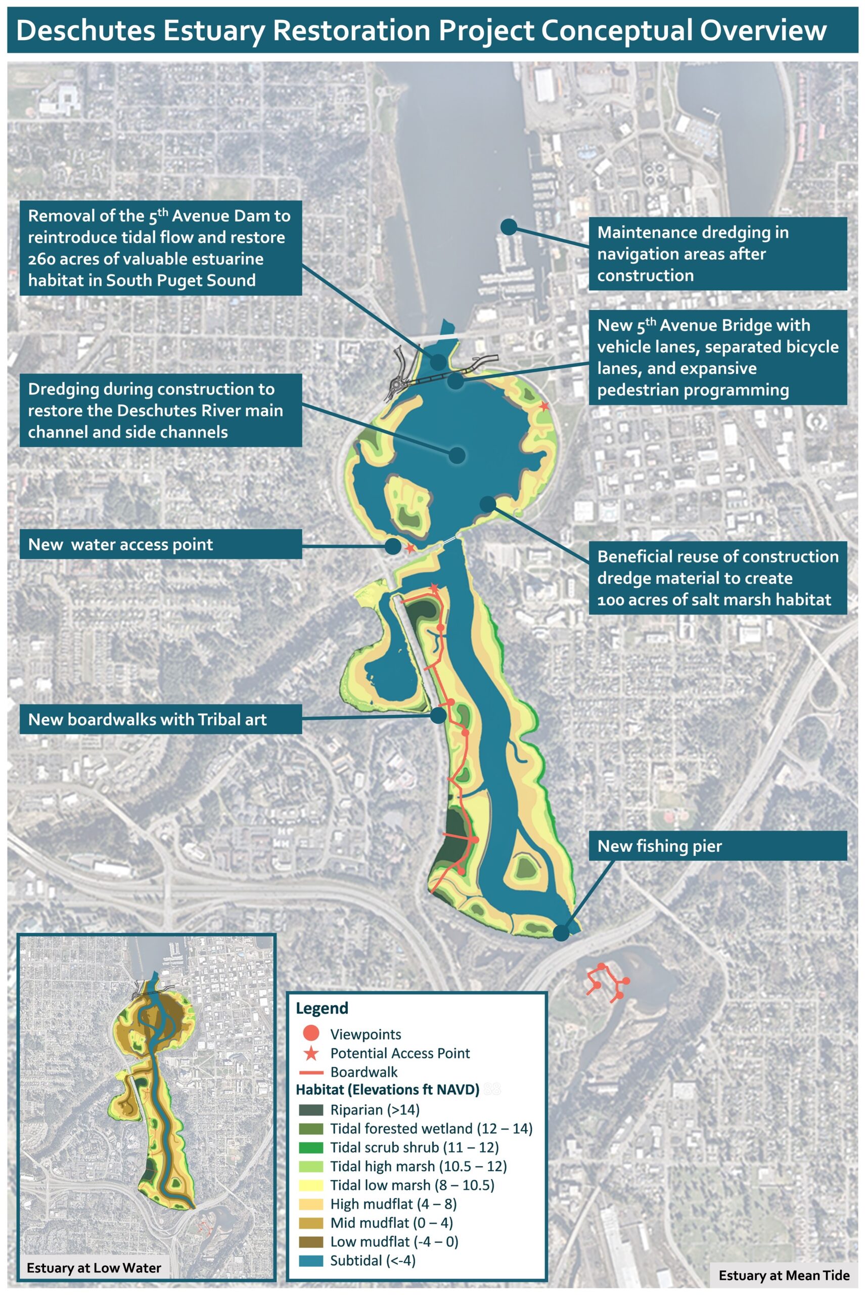
Removal of the 5th Avenue Dam will restore unrestricted access to 2 miles of the lower Deschutes River, increasing the amount of productive habitat for salmon, other anadromous fish species (fish that migrate upriver from the sea to spawn), marine fish, and shellfish in the area. Coho salmon are listed as a species of concern in Puget Sound, and the Deschutes River provides important habitat for this population. Listed chinook and steelhead also use the waters of southern Puget Sound, including Budd Inlet and the project area. Shallow water habitats with salt marsh vegetation along the shoreline will also provide preferred forage and rearing habitat for juvenile salmon. With improved habitat, it is possible that salmon run numbers will increase over time. Habitat improvements will also benefit waterfowl, nearshore and marine birds, and smaller mammal populations.
4. When will this project be complete?
Design began in October 2023 and will occur over an approximately 3- to 5-year duration contingent on funding. Permitting is anticipated to begin in 2025 and to conclude concurrent with the design process. Construction could begin as early as mid-2027, if design and permitting are completed on schedule and if construction funding is obtained during the design and permitting process such that there is no delay between project phases. If only partial funding has been obtained, DES would evaluate whether phased construction could begin with discrete project elements while the remaining funding is pursued. A construction duration of approximately 6 years was estimated during the conceptual design period, with dam removal occurring in the early 2030s if funding is received to enable full construction without delay. The contractor will identify opportunities to compress the schedule, as appropriate, which could also result in reduced construction costs.
5. How does the public get to engage with this project?
DES completed a State Environmental Policy Act-required EIS, which culminated in 2022 with a Notice of Action Taken and determination of estuary restoration as the preferred alternative for long-term management of the waterbody. This included a robust public engagement process, during which DES engaged with the Squaxin Island Tribe, governmental and agency partners, and the community at large, and provided formal comment periods to solicit input regarding proposed alternatives. Estuary restoration was selected by DES as the preferred alternative for the long-term management project because it was determined to best achieve project goals and provide other environmental benefits, was determined to be environmentally and economically sustainable, and had the broadest stakeholder support. As the project moves through design and permitting, the public will have opportunities to provide informal input to the design process and provide formal public comment for several of the required permits. Details on upcoming opportunities for public involvement will be shared on the meetings page of the project website and via the project newsletter, which can be subscribed to on the project website. There also is a Community Sounding Board (CSB), which provides input to DES throughout the project. CSB members are listed on the project website and include representatives from several local organizations that support and facilitate public involvement.
6. Why is there so much work involved with estuary restoration? Why not just open the tide gates on the existing 5th Avenue Dam?
Removal or opening of the 80-foot tide gate (only) to restore tidal flow was considered in 2019 as project alternatives were evaluated and identified for the EIS. A Measurable Evaluation Process (MEP) evaluated discrete concepts and alternative variations that had been proposed by governmental and agency partners and the community through past planning processes.
The MEP determined that tide gate opening (only) was moderately feasible from a technical standpoint but did not meet regulatory feasibility or environmental sustainability criteria. Concepts evaluated in the MEP were reviewed by the project team, regulatory agencies, local municipalities, and the Squaxin Island Tribe. Through this process, it was determined that tide gate removal or opening (only) would not meet project goals for water quality or ecological functions as well as a full dam removal (80-foot tide gate and the 420-foot earthen dam) and creation of a larger 500-foot opening at 5th Avenue would. Simply, a restoration project should restore ecological functions, and many ecological functions would continue to be impacted under a scenario where the dam still exists and flushing and fish passage remain restricted.
One of the other major considerations for this concept was that the narrower 80-foot opening would increase flow velocities, resulting in more scour and greater need for downstream protection and associated infrastructure costs. Sediment management was also identified as a primary project goal to manage over 70 years of accumulation and to minimize deposition in navigational areas in West Bay. The concept of opening the tide gates (only) would not address the need for sediment management. Therefore, full dam removal with the habitat creation from dredged sediment was ultimately put forward as part of the Estuary Alternative. Tide gate opening did, however, meet high economic sustainability criteria.
Design Components
7. What is the design concept for the new 5th Avenue Bridge?
The Project is an opportunity to both replace the aging 5th Avenue Bridge and create better connectivity for the public with the newly restored estuary and adjacent public parks and downtown center. The new 5th Avenue Bridge will be an architecturally unique structure and a notable landmark in the capital city. The bridge will have some resemblance to the 4th Avenue Bridge, while still having its own signature style will enhance community connection to the estuary. The current design includes expansive pedestrian space on the south side of the bridge; expansive views toward the Capitol Campus; and separated bike, pedestrian, and vehicle lanes in both directions. An oculus is being designed in the middle of the pedestrian space for viewing of the restored Deschutes River channel. A rendering of the design concept for the new 5th Avenue Bridge is provided below.
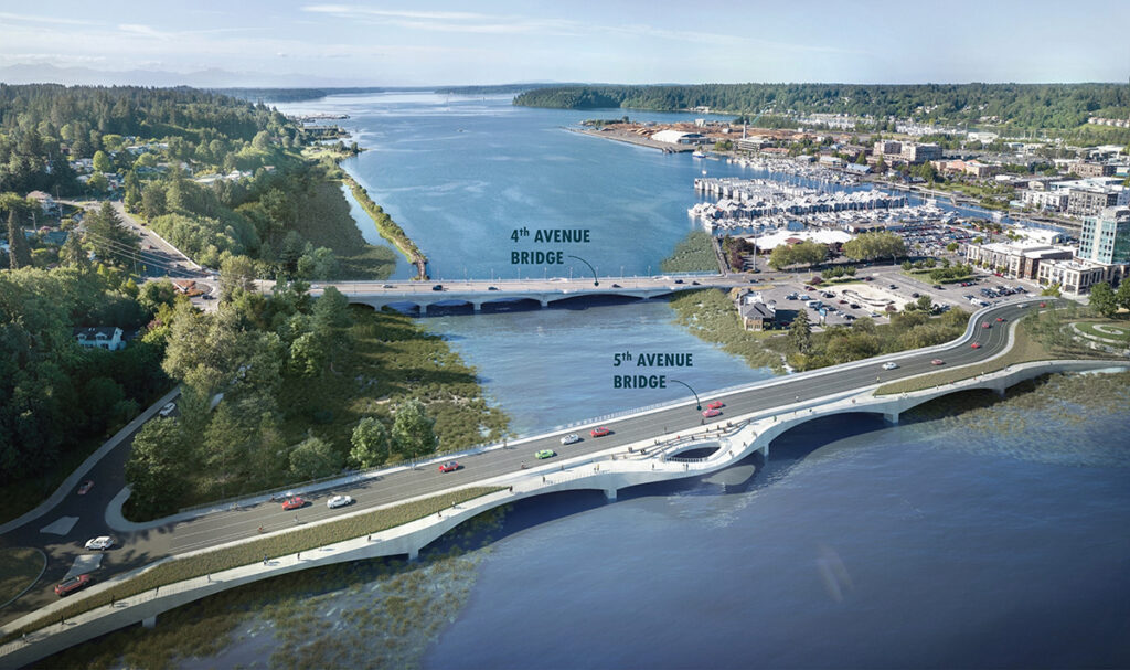
8. What are the revised traffic considerations in the project area?
To allow for continued use of 5th Avenue during construction, the new 5th Avenue Bridge will be constructed slightly south of the existing bridge and the roadway connection to Deschutes Parkway will be reconfigured. The new bridge and adjoining roundabout speed limits will be set at 25 miles per hour and will provide accessible, low-stress travel opportunities for more people. The new bridge is designed with 11-foot-wide vehicle lanes and 5-foot-wide bike lanes separated by a 3-foot buffer. Additionally, 5th Avenue will have an 8-foot-wide sidewalk along the north side and a minimum 8-foot-wide sidewalk width on the south side of the bridge, in addition to the expanded pedestrian space. The new bridge and roadway design will accommodate increased usage into the future as the regional population grows.
9. How will the new habitat be constructed/restored?
Dredging will occur in the Middle and North Basins at the beginning of estuary restoration to reestablish the historic main channel and side channels of the Deschutes River. Sediment dredged during construction will be placed along the shoreline and eventually graded to create the new target habitat types. Long-term stability of the habitat is largely ensured by creating shallow slopes and planting. Gravel berms may be used to increase long-term stability in the locations where a shorter incline to higher elevations is needed. A map of the 15% design for estuary restoration is available here. No active habitat restoration is proposed for the South Basin, because that habitat is already healthy and conducive to future conditions.
10. How will recreation be improved by this project?
The Heritage Park Lo0p Trail, including the pedestrian bridge that connects the east and west side of the North Basin, will remain, although the path through Heritage Park will be reconstructed as part of the work to improve sea level rise resiliency. Dedicated bike lanes and improved pedestrian space will be integrated into the new 5th Avenue Bridge. A trail extension will be constructed to connect the Heritage Park Loop Trail to the future trail system that will be restored along the western shoreline of West Bay, as part of a separate project led by the City of Olympia. Elevated boardwalks will be constructed along the western shoreline of the South and Middle Basins with views to the shoreline habitat areas. These boardwalks will feature Tribal art and educational interpretive signage. Boardwalks are not proposed for the east side of the Middle Basin, because it is not open to public access. A few water access points will be established in the North Basin, including at Marathon Park. The approach to water access is still being developed, but could include a mix of touch points, overwater viewing, in-water steps, or access via hand-carried watercraft. The fishing pier at the south end of the South Basin will also be reconstructed.
11. How will Tribal history and the history of the region be represented within the project area?
DES has engaged Andrea Wilbur-Sigo, an artist and member of the Squaxin Island Tribe, to conceptualize the types of Tribal art that may be integrated throughout the restored estuary. Along with members of the Squaxin Island Tribe, Andrea will identify the stories with most importance for this landscape and develop art programming during the design process that will be highlighted throughout the landscape. DES has also gathered input from the community on important historical, cultural, and environmental elements to incorporate into the design; this coordination will continue throughout the design process.

12. Is Percival Creek being improved as part of this project?
Habitat restoration will occur throughout Percival Cove but does not extend upstream into Percival Creek. The foundations of the existing Percival Cove Bridge cannot support the proposed channel modification, and the bridge is nearing the end of its design life. Based on the current age and condition of the bridge and the channel improvements, the Percival Cove Bridge will be replaced—this replacement will more than double the channel width available for Percival Creek as it discharges into the Deschutes Estuary. The City of Tumwater is leading a range of projects that benefit habitat across Percival Creek upstream of the Deschutes Estuary Restoration Project area.
13. How will the project address stormwater?
The project will increase the amount of pollutant-generating impervious surface in the project area as a result of the new 5th Avenue Bridge construction and roadway reconfiguration. Stormwater from the bridge will be conveyed to a biofiltration treatment system constructed on the west side of 5th Avenue. Biofiltration is currently considered to be the best form of treatment for 6PPD-quinone (6PPDQ), which is an emergent chemical of concern that is released to the environment when tires are worn down by friction with the roads.
Side channels within the new habitat have also been designed at areas of stormwater discharge from adjacent outfalls. These outfalls are managed by local municipalities and the Washington State Department of Transportation under permit authorization from the Washington State Department of Ecology.
14. How will design and construction progress over the coming years?
Design and permitting began in late 2023 and is expected to occur over a 3- to 5-year period, assuming additional funding is secured without delay. In this process, all components of the estuary restoration (e.g., habitat areas, dam removal, bridge, and boardwalks) will be designed. Plans and specifications will be reviewed by design partners and regulatory entities at the conceptual, 30%, 60%, 90%, and final design stages. During the design period, DES will also obtain permits from federal, state, and local agencies; these are needed before construction can begin. Construction is anticipated to take approximately 6 years and could begin as soon as mid-2027. The construction schedule and implementation planning will be determined in coordination with a selected General Contractor/Construction Manager starting at 60% design.
Ecological Functions
15. What are the ecological functions addressed through restoration of the estuary?
Restoration of the Deschutes Estuary will reestablish over 200 acres of estuarine habitat including 100 acres of salt marsh, habitat that has been greatly diminished and degraded because of historical development patterns. In addition to supporting key ecological processes, reintroducing estuarine conditions will provide productive habitat for shellfish, salmon, other anadromous fish species (fish that migrate upriver from the sea to spawn), and marine fish in the area. Shallow water habitats with salt marsh vegetation along the shoreline will provide preferred forage and rearing habitat for juvenile salmon. The freshwater aquatic plants that dominate the basin today will not persist and most of the aquatic invasive plant and animal species that exist in the freshwater system will be eradicated. Climate resiliency will be increased across the City of Olympia by reducing maximum flood elevations by up to approximately 1 foot compared to with the dam in place. The project also provides an opportunity for carbon sequestration, because salt marsh habitat sequesters more carbon than the existing freshwater lake. Learn more about shoreline habitat here.
16. How will this project improve water quality within the waterbody and Budd Inlet?
Historically, Capitol Lake has suffered from a variety of water quality problems, as evidenced by aquatic weed infestations, algal blooms, closure of the swimming area due to bacteria concentrations, and restrictions on boating and other beneficial uses. Even so, contact with the water within the current Capitol Lake is not hazardous to human health. There are a number of factors that affect the water quality and overall aquatic health of the existing Capitol Lake aquatic ecosystem; of greatest concern is the impact to dissolved oxygen conditions downstream. The Washington State Department of Ecology Draft Total Maximum Daily Load (TMDL) for Budd Inlet describes Capitol Lake as the largest source of low dissolved oxygen conditions in Budd Inlet. Modeling indicated that estuary restoration was the only alternative assessed during the EIS process that could meet water quality standards.
17. How will this project address sea level rise?
After dam removal, maximum flood levels across the City of Olympia could be lowered by approximately 1 foot. The project team is currently designing a habitat berm along the shoreline of Heritage Park to raise the shoreline elevation and interrupt a primary flooding pathway into downtown. The elevation of the new 5th Avenue Bridge and other infrastructure constructed as part of this project has also been set to be resilient to rising sea levels in the future. Sea level rise adaptation measures will continue to be coordinated between the Deschutes Estuary Restoration Project and the City of Olympia Sea Level Rise Response Plan.
18. How will invasive species be addressed?
With introduction of saltwater after dam removal, the freshwater aquatic plants that dominate the basin today will not persist and most of the aquatic invasive plant and animal species that exist in the freshwater system will be eradicated. The invasive New Zealand mudsnail and purple loosestrife plant have some tolerance to saline conditions, and although the population is expected to be dramatically reduced, there may be some survivability in areas of freshwater input (e.g., Percival Cove). There is no existing evidence of significant ecological harm from low density populations of New Zealand mudsnail that can exist in saline environments. During the permitting process, an aquatic invasive species (AIS) adaptive management plan will be prepared with measures for monitoring and adaptation to minimize potential impacts from AIS or other nuisance species. DES will continue to coordinate with the Washington Department of Fish and Wildlife to determine the right approach for decontamination as design progresses. Additionally, educational signs could be posted warning recreationalists of the presence of New Zealand mudsnails and other high-priority AIS, and their potential to spread.
19. How will sediment be managed in the estuary and West Bay?
Dredging will occur in the Middle and North Basins during estuary restoration to restore the historic main channel and side channels of the Deschutes River. Sediment dredged during construction will be beneficially reused within the project area to create new shoreline habitat areas. Once the estuary is restored, sediment transported by the Deschutes River will continue to deposit, move, and shift within the estuary, and natural sediment will flow through the estuary and deposit in West Bay or further out into Puget Sound. Sediment accumulation will be monitored at least annually along the eastern shore of West Bay where there is recreational and commercial navigation. Numerical modeling predicts that, on average, focused maintenance dredging will be needed in West Bay on a 6-year frequency, along the eastern shore of West Bay, at the Olympia Yacht Club and private marinas, in areas of navigational access between these resources, and at the Port of Olympia. Maintenance dredging to support the existence of commercial and recreational navigation in the former Deschutes Estuary occurred in these areas before the 5th Avenue Dam was constructed. Shared funding will be provided by members of the Funding and Governance Work Group (FGWG) through 2050 for the maintenance dredging, as described in the ILA (refer to FAQ #20). Dredging will not occur in the restored estuary after construction.
Funding and Governance
20. How is this project being funded?
The project is funded for a portion of design and permitting through an initial allocation by the Washington State Legislature through the Climate Commitment Act. The Squaxin Island Tribe was awarded $6.4 million for fish barrier removal in South Puget Sound. DES sponsored the Tribe in their submittal for this funding opportunity, and much of this grant funding will be used to advance Deschutes Estuary design and permitting. Additional funding is needed to complete design and permitting, and DES is actively pursuing a variety of grant opportunities and legislative appropriations.
Construction funding will rely on funds from a variety of sources, including federal and state appropriations, and grant funding opportunities. After construction, shared funding will be provided by members of the FGWG through 2050 for West Bay maintenance dredging, as described in the signed/executed ILA.
21. Who will manage the estuary after it is built?
DES and its project partners finalized an interlocal agreement (ILA) for long-term governance and funding of the restored Deschutes Estuary after the project is complete. DES received the final signature on November 12, 2024. DES led development of the ILA in partnership with the Squaxin Island Tribe, the cities of Olympia and Tumwater, Thurston County, Port of Olympia, and LOTT Clean Water Alliance. All are members of the project’s FGWG. The agreement was developed during a yearlong process to transition a Memorandum of Understanding into this legally binding document. Specific governance responsibilities for each signatory can be found in the ILA. After DES has secured sufficient funding to begin construction, signatories of the ILA will make annual payments to support sediment management in West Bay, beginning after dam removal and extending through 2050. An initial payment schedule is included in the final ILA.
The aquatic lands of Capitol Lake are managed by DES under long-term lease agreement from the Washington State Department of Natural Resources. The current lease agreement was established in 1998, for a term of 30 years (through 2028), with the option for one 20-year extension (through 2048). The existing lease authorizes DES to provide public recreation and operation of parks, public access, public parking areas, and lake management activities. Future in-water and nearshore maintenance and monitoring will be defined in close collaboration with the regulatory agencies and Tribes during the permitting effort.
22. Will DES monitor the project area once the estuary is restored?
Requirements for monitoring during and after construction are defined in close collaboration with the regulatory agencies and Tribes during the permitting effort. There maybe be opportunities to provide data collected during this monitoring to the Squaxin Island Tribe, agencies, or local non-profits for further study and education.
Project Partners and Regional Benefits
23. Are local Tribes engaged in this project?
The Deschutes Estuary Basin is the ancestral home to many of the Squaxin Island Tribe’s members. The Squaxin Island Tribe has been actively involved in the long-term planning for the estuary restoration project. The Squaxin Island Tribe is an integral part of the project visioning and execution and will help guide design of features across the restored landscape, including estuary design and habitat types, traditional plantings, and boardwalks, as well as fishing and water access points. There is great opportunity for Tribal art, history, and knowledge to be integrated throughout the restored estuary. Removal of the 5th Avenue Dam and restoration of the estuary system will have beneficial effects for ecological, cultural, spiritual, educational, and economic values for the Squaxin Island Tribe. It is important to note that during the EIS process, the Squaxin Island Tribe stated that estuary restoration was the only alternative that they support. This input, and potential effects to Tribal resources, were considered in the process to identify the preferred alternative.
24. Who is involved in this project?
The current Capitol Lake is located on the Washington State Capitol Campus and is managed by DES.* DES and its multidisciplinary consultant team are leading this restoration effort. Primary partners and stakeholders include the Squaxin Island Tribe,* City of Olympia,* City of Tumwater,* Thurston County,* Port of Olympia,* LOTT Clean Water Alliance,* Washington Department of Fish & Wildlife, Washington State Department of Natural Resources, and the community at large. A Memorandum of Understanding was developed in 2022 with the members of the project-specific FGWG. FGWG members recognize that after construction of the estuary, continued governance of the project and funding of sediment management in West Bay will be necessary to contribute to the health of Budd Inlet and the Deschutes River watershed and will help maintain a working waterfront and recreational boating. The FGWG members transitioned the MOU into a legally binding Interlocal Agreement in November 2024. * = FGWG Members
25. How is this project related to planned sediment cleanup activities at the Port of Olympia?
Remediation of aquatic sediments in lower Budd Inlet is a critical part of the ongoing effort to improve the health of the Deschutes River Watershed, but it is a separate project from the Deschutes Estuary Restoration Project. The Port of Olympia’s remediation project to address dioxin and polycyclic aromatic hydrocarbon exceedances within West Bay sediments is required by the Washington State Department of Ecology’s Model Toxics Control Act (MTCA) to restore the health of the marine environment and to protect the health of consumers of fish and shellfish. The Deschutes Estuary Restoration Project is being implemented to improve water quality and ecological functions, to restore active community use, and to manage future sediment deposition. Sequencing between the two projects is important. The Port’s sediment remediation in West Bay is sequenced to be complete before removal of the 5th Avenue Dam occurs as part of the Deschutes Estuary Restoration Project.
26. How is the City of Olympia Sea Level Rise Response Plan being incorporated?
To address flooding vulnerabilities of downtown Olympia and its combined sewer system, the City of Olympia, LOTT Clean Water Alliance, and the Port of Olympia prepared an Olympia Sea Level Rise Response Plan. The Response Plan is focused on increasing resiliency of the City of Olympia from the effects of rising sea levels. Aspects of this Response Plan have been referenced and incorporated into the Deschutes Estuary Restoration Project conceptual design. Hydrodynamic and sediment transport numerical modeling conducted for the Deschutes Estuary Restoration Project in 2020 incorporated relative sea level rise projections consistent with those used in the Olympia Sea Level Rise Response Plan. The estuary and new 5th Avenue Bridge designs use the Olympia sea level rise projections and associated regional updates to ensure that the new infrastructure constructed as part of the project will be resilient over the long term, and that the estuary habitat will adapt to and accommodate future increased water levels. With dam removal, maximum flood levels across the City of Olympia could be lowered by approximately 1 foot.
27. What are the benefits to the local community and economy?
The project will result in improvements to ecosystem vitality and watershed health, including habitat for native and commercially important species including salmonids, expanded recreation infrastructure, and restored in-water use. Restoration of active public use of the waterbody with new boardwalks, water access points, a fishing pier, habitat areas, and restored water-based recreation will benefit development and commerce in downtown Olympia. Additional recreation activities and enhanced pedestrian paths between areas of downtown are anticipated to draw potential customers to the business district. The project will also result in enhanced economic, cultural heritage, spiritual, and educational value associated with ecosystem restoration for Tribal populations, addressing equity and social justice impacts of existing conditions.
Climate resiliency will be increased across downtown Olympia by reducing maximum flood elevations by approximately 1 foot compared to conditions with the 5th Avenue Dam in place. It is anticipated that there will be reduced, avoided, or deferred regulatory compliance costs for LOTT Clean Water Alliance, and therefore Thurston County residents, with improved water quality and stormwater infrastructure compared to current conditions. In addition to long-term benefits, construction spending will temporarily support jobs, labor income, and economic output.
28. How does this project benefit Puget Sound?
This project will have great benefits to the Puget Sound aquatic ecosystem. Restoration of the estuary will provide productive habitat for shellfish, salmon, and other anadromous (fish that migrate upriver from the sea to spawn) species, including aquatic species listed as threatened under the Endangered Species Act. Creating foraging and resting habitat will serve as a key step in restoring productive migratory fisheries in South Puget Sound and advancing orca recovery. The project will also address chronic water quality violations by improving dissolved oxygen conditions in Budd Inlet and produce habitat that will better sequester carbon than existing conditions. The project will include educational interpretive materials that will increase public understanding and observation of ecosystem restoration and its benefits to the watershed and Puget Sound, with potential application to improve success and reduce costs of future Puget Sound estuary restoration projects.
29. What will civic and environmental education look like once the estuary is restored?
Interpretive signage and public art—created by Tribal artists—will be integrated throughout the project area including on the new 5th Avenue Bridge and along the boardwalks. Place-making enhancements such as these will help provide education about the connections between the estuarine ecology and cultural importance of the resources it supports. DES will continue to engage with community to determine how to best support civic and environmental education in the future.